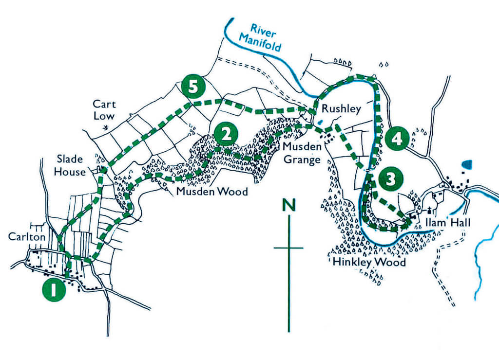
WE have a lovely stroll this month in the pleasant surroundings of Calton, Rushley and Ilam, through the luscious Musden Wood.

© Crown copyright, 11/2022, Ordnance Survey 200314.
| Start | St Mary’s Memorial Hall, Calton |
| Distance | 6miles (9.6km) |
| Parking | There is a small car park in front of St Mary’s Memorial Hall |
| Terrain | Country lanes, good paths and tracks across fields |
| Ascent | 987ft |
| Taken from | The Peak District Pack is the ultimate walker’s companion, combining 20 concise routes together with professional mapping on handy weatherproof cards, which can be taken on the walks in a map case provided. You can save £4 on the RRP of £14.95 if ordered direct from the publisher – at walking-books.com There is also a flat rate of £2 postage on all orders up to £19.99 |
There is also a special offer on a three-volume bundle of 50 Peak District walks: the Peak District Pack, the Peak District Pack 2 and Making Tracks, illustrated and written to allow children to lead the walks. The offer from the publisher takes £10 off the RRP of £42.85, along with free delivery.
Route
- With the church behind you, turn right and walk along Back Lane. Just after the brick townhouse on the left, turn left through the gate down the public footpath between the buildings to reach the other Back Lane – at the back! Go through the gate and turn right to walk along the road, following it past the water works on the left as the road bends to the right. Find the footpath sign on the left, and take it to walk along the line of the trees. At the track crossing left to right, go through the gate ahead and make your way towards the fence straight ahead – keeping to the left of it. Follow the clear path on the ground as it runs to the right, then left, as the sides of the valley rises up more on the right, but also rises on the left. The path heads into a small wood, before emerging for a little section and then plunging into Musden Wood.
- Continue to make your way through the wood until the path exits the wood, with some farm buildings on the left. The path joins a farm track and turns to the right. At the farm, turn left to walk alongside the building and then the fence to the gap at the end. Here, turn right and head straight across the field to the far gate. In the next field, follow the line on the ground to go between some trees to get to the footbridge over the River Manifold. Cross over the river, and turn right.
- Immediately, there’s a junction to the left – don’t take this but continue straight on to keep the wood on the left and the river on the right. As the path bends to the left, the river goes further away and you are back in the trees again – but only for a short while before meeting the rear of the YHA’s Ilam Hall youth hostel. Turn left after the Buckhouse/Tea Room, and with the hall on the right, take the diagonal track on the left. The track gives way to a path, which crosses the grass and cuts through the line of trees to return to the path near the footbridge over the River Manifold. Turn right and, instead of crossing the bridge again, continue on the path beside the river on your left.
- After a pleasant stroll alongside the river, the Manifold turns to the left, and the path turns away to join Lodge Lane. Climb over the stile and turn left to walk along the road, past River Lodge on the left to eventually reach Rushley Bridge. Ignore the footpath on the right and cross the bridge. You are now in the village of Rushley. Follow the road as it bends sharply to the right, and then after a drive opening to a farm, find the public footpath on the left. Go through the kissing gate and head towards the gate in the far wall. Once through, do the same for the next wall, and then follow the wall on the right to the opening at the end. Here, head in an easterly direction to the stile, which is roughly halfway along the far wall.
- Once over the stile, keep the occasional wall to your left and follow it along the length of one field, and then another, to eventually walk between two walls and around the back of a house. Turn left at the house, and then the footpath pretty much follows every line of tress – while keeping to the left of the trees. At Farwell Road, turn left and left again onto Back Lane, then turn right to retrace your steps to the church via the public footpath.


