WE have been asked by readers many times if we would consider doing a cycle ride in the Out & About column.
Well, this month we have devoted the column to such a ride – and one that starts where you can hire a cycle or even an e-bike.
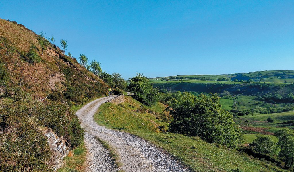
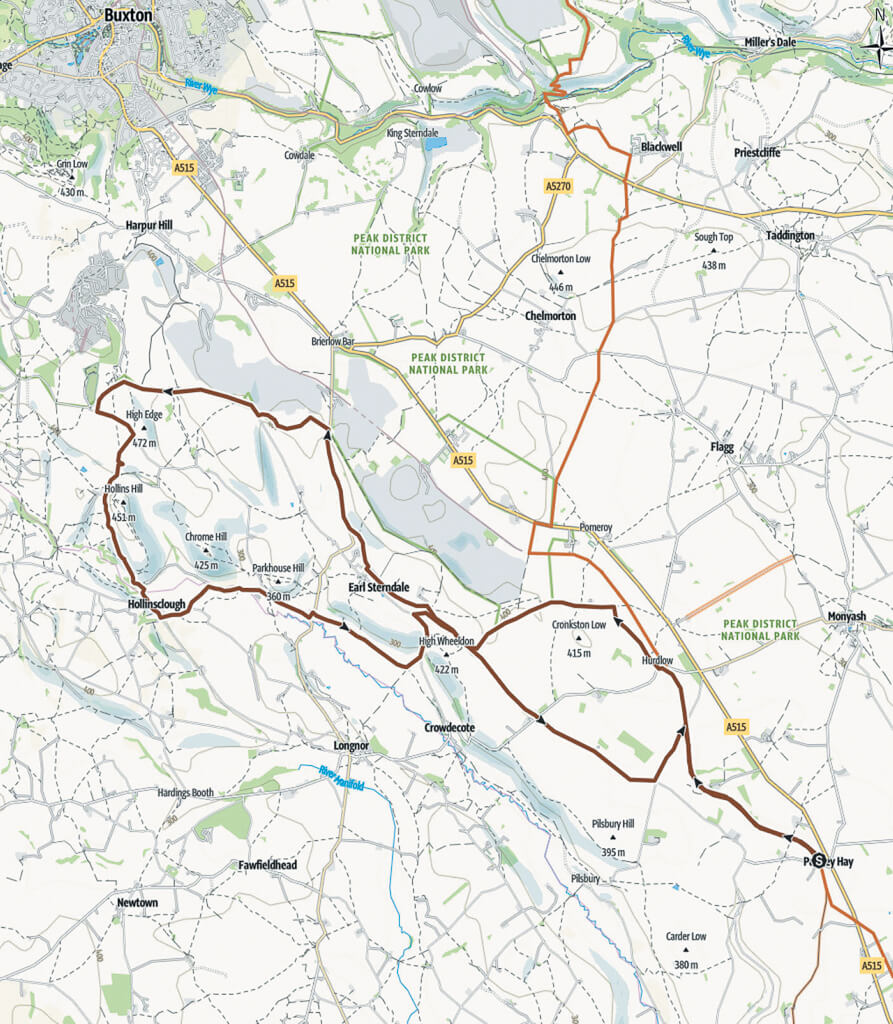
This ride circumnavigates Chrome and Parkhouse Hills. The route starts on the High Peak Trail, leaving it at the end of the trail to follow tracks and quiet lanes to Earl Sterndale. The route also takes in Hollinsclough, where there are great views of Chrome and Parkhouse Hills, which are limestone apron reefs deposited about 330 million years ago when the area was covered in tropical seas and was quite close to the Equator! Finally, we’re back on to the High Peak Trail for the return to Parsley Hay.
Parsley Hay was once one of the highest railway stations in England. It was on the High Peak Railway which used to connect the canals at Whaley Bridge and Cromford.
*The maps are copyright © OpenStreetMap contributors and © Outdooractive Cartography; Germany. The data is available under the Open Database Licence at Open Street Map, www.openstreetmap.org/copyright
| Start & Finish | Parsley Hay car park (pay and display), SK17 ODG. There is a café and toilets, along with cycle hire |
| Distance | 17miles (28km) |
| Terrain | This route is a varied ride on mixed terrain. There are a number of climbs and gentle descents. The terrain is good but does contain some grass and stone tracks. There is a very short section (about 50 metres), where the route drops away from the track to the River Dove (point 7). This can be walked if necessary. This ride will suit those on e-bikes or those with a reasonable level of fitness |
| Taken From | Scenic Cycling in the Peak District (£12.99), by Carina Humberstone, published by Spiral Books (spiral-books.com). Featured are 19 circular rides of varying difficulty, with options for all abilities and different types of bicycles, including e-bikes |
Route
- From the café and cycle hire at Parsley Hay, turn right along the High Peak Trail, go for 5.5 kilometres to the end of the trail. Turn left to climb a stony track, then descend down to a lane. Turn right on the lane to climb and then drop down to High Wheeldon. You will see the pyramidal shape of Wheeldon Hill in front of you, topped with a trig point.
- At the T-junction in front of Wheeldon Hill, turn right to follow the lane, as it gently descends. About 1.2 kilometres from the T-junction, as the road bends to the left around a farmhouse, take the rough track that goes straight ahead. Ignore another rough track to the right, instead keep straight on towards the houses, continuing to a T-junction by the church and primary school. Turn right here, climbing slightly, then bend left, passing more houses before reaching the road to Longnor and the A515
- At the T-Junction with the road, turn right and climb steadily to the top of the hill. This road is not busy but traffic can travel fast. Pull over to the left at the brow, looking down towards the quarries.
- Turn left here, through the metal gate, signposted ‘Bridleway’ on a wooden finger post and climb gently up the track, through a field often filled with cows. The gate at the top is usually closed; pass through this and bear leftwards, cutting across the left-hand corner of the field to reach a wall. Follow the wall on your left until a gate blocks your way. Go through this gate and follow the track as it bends gently around to the right, to another gate. Go through this next gate, descending gently towards the lane and two gates in the corner of the field.
- Ignore the gate straight ahead which goes onto the lane, instead go through the gate on the right and follow the wall on your left, to a small wooden gate onto the lane about 1 kilometre further on. Go through the gate here, to join the lane and follow it to the right, over a cattle grid, to Buxton Raceway (a banger circuit). Turn left here, almost behind you, before another cattle grid; towards Booth Farm. You can cut the corner here at the Raceway, following the fence line across the small grass triangle on the left, to the other lane.
- As you approach the crest of the hill, take the road on the right, immediately before another cattle grid. The descent winds down steeply, with a hair-pin bend, to Booth Farm. As you approach the farm but before reaching the buildings, bear left (essentially keeping straight on) over a cattle grid, onto a stony track. Follow this track with the sandstone edge on your left and a drop to lower ground on your right.

- Keep left at the lonely house, leaving the building on your right. Immediately past the house, keep right on the lower track, continuing mainly downhill. This can be muddy and slippery in wet conditions. Soon after passing through a gate, there is a sign ‘Private Land, No Access or Shooting’. Turn right at the finger post here onto a narrow, rutted bridleway which can be tricky to ride. Watch out for the bridleway sign, turning abruptly right into the woodland. This zig-zags down to the stream and a ford, however, an easier alternative is to keep straight ahead, walking your bike along the footpath through the gate and across the bridge.
- Once across the stream, there is a gentle but challenging, short ride (or push) up to the road. This section from the track, across the river and up to the road can get very muddy in wet conditions. If you end up walking from the fingerpost in point 7, to the road, it is only about 200 metres.
- Turn left on the lane and descend into Hollinsclough. Take the first left at the little, grassy traffic island, before the telephone box, to follow the road past the school. As you leave the village, the views open up towards Chrome and Parkhouse Hills once again. About 250 metres from the school, take the track on the left, past a solitary house. Follow this track as it bends to the right at a junction, passes through a gate and then down to a ford. (You can push your bike across the footbridge here).
- If you tackle the ford, be prepared for the climb out of the river on the other side. Follow the track between the gate posts, to a lane. Bear right on the lane and follow it to a T-junction at Glutton Bridge.
- Turn left at the T-junction, then immediately right opposite a yard and MOT centre. This lane is generally flat with a number of gates on it. After the last gate at the farm, the lane bends around to the left and comes to a T-junction. Turn left at the T-junction, passing the old quarry (and popular climbing spot) of Aldery Cliff, as you climb up towards Earl Sterndale.
- As you come out of the tree cover and the road levels out a little, look for a track almost behind you, on the right, immediately before a house. Climb this gently up to another lane. Turn right on the lane and continue climbing past Wheeldon Trees. Soon the road descends to a crossroads at High Needham.
- Go straight across at the crossroads, looking out for the next crossroads in about 1.7 kilometres. Turn left and cycle easily towards the bridge where the High Peak Trail crosses the road. Immediately before the bridge, take the steep path on the left, up to the High Peak Trail. Turn right on the trail, to return to Parsley Hay.


