With work having started on the latest phase
of the canal’s restoration in Staveley, Rod Auton
looks at the prospect of Chesterfield ever being reconnected by canal to the River Trent.
A bit of history
The Chesterfield Canal was officially opened on June 4, 1777. The ensuing two-and-a-half centuries have seen many ups and downs in its fortunes. In its very first decade, income was hit by the recession caused by the loss of the American colonies, but it eventually settled down to be moderately prosperous.
The coming of railways did not affect our canal as badly as some others, but the major collapse of the Norwood Tunnel in October 1907 meant that the Derbyshire section was cut off from the rest of the canal.
By the 1960s, the whole canal was in a dreadful state. The British Waterways Board was keen to close it, but a protest movement had grown up to oppose this threat. The 1968 Transport Act said that the Chesterfield Canal should be a cruiseway from the River Trent to Worksop, and a remainder waterway to the Norwood Tunnel, but disregarded the Derbyshire section. Much of this was sold off, including land in Killamarsh, where 30 houses and garages were built on the line of the canal.
Although the canal had not been closed, it was in a very sorry state.
The section from Chesterfield to Staveley was just a tiny stream amongst weeds in most places, but it had to be kept open because a clause in the 1771 Act of Parliament that said that a water supply must be maintained to Staveley Forge. In 1987, Derbyshire County Council (DCC) bought this section from British Waterways primarily because they wanted to build the Brimington/Staveley bypass on top of it.
Previous restoration
In 1976, the Chesterfield Canal Society was formed, becoming the Chesterfield Canal Trust (CCT) in 1998. Volunteers from CCT decided to restore Tapton Lock, which opened to much fanfare in 1990. This was the first lock to be restored and subsequently the volunteers restored three more locks in Chesterfield and built two new ones. DCC lifted bridges at Station Road, Brimington and Bilby Lane and the canal was dug out, meaning that navigation from Tapton to Mill Green became possible in 2002. The DCC Countryside Service now manages this stretch of canal.
On the eastern end of the canal, British Waterways restored 30 locks between 1996 and 2003 and built a new one to compensate for subsidence.
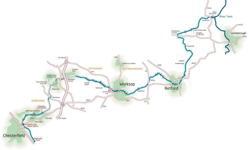
On the 20 miles from Worksop to Chesterfield that were derelict, over 12 miles have been restored along with 34 locks plus three new locks and 11 bridges.
Most of this had been done in the decade up to 2003, much of the work paid for by derelict land grants and European money. The assumption was that the remaining eight-and-a-half miles would soon follow. However, three major events conspired to stop that happening – the financial crisis of 2008 and subsequent recession led to huge cutbacks in all public spending; the announcement that HS2 was to cross the line of the canal in eight different places; and, finally, the Covid pandemic.
Some restoration was done, but on nothing like the scale of earlier. DCC built Staveley Town Basin with a European grant, and the CCT volunteers built the abutment walls for the new Constitution Hill bridge, a 600m retaining wall from Mill Green to Hall Lane, the brand-new Staveley Town Lock and the 300 metres of Hartington Harbour.
Current restoration work
In 2020, the levelling-up fund called the Staveley Town Deal was announced. The Chesterfield Canal Trust was awarded £5.8m of this Government money for restoration and Derbyshire County Council was awarded £2.2m to start developing Staveley Town Basin.
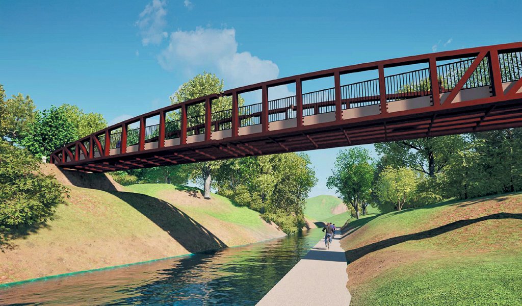
After much preparation, the restoration work at Staveley started in April. The first stage is the construction of a new Trans Pennine Trail bridge, which will be 38 metres long and nearly 10 metres above the canal. It will be lowered into position in late July or early August.
After that the canal itself will be restored from Eckington Road bridge through to Bellhouse Basin at the bottom of Bellhouse Lane. It is not certain how much further the canal will go – it depends upon how far the money will stretch. However, the towpath will be built all the way through to Renishaw, creating a new 3m wide multi-user trail.
There will be a new accommodation bridge at Bellhouse, a new lock and a pumping system to carry the water from Staveley Town Basin to the new section.
The new lock will be named Keith Ayling Lock as a permanent memorial to the former chair of the Chesterfield Canal Trust who is widely regarded as the most influential figure in the restoration of the canal.
The final part of the lock construction will be the fitting of the new gates, so the Chesterfield Canal Trust is running an appeal to raise money towards their cost.
This work will be complete by the end of 2025. Meanwhile, Derbyshire County Council will shortly be undertaking the first stage of developing Staveley Town Basin, including a new building with a café.
Future restoration
The cost of restoring the remaining eight miles between Staveley and Kiveton Park will run into many tens of millions of pounds. It has been splitt into seven sections (see below). Much of this land is currently in private hands and it is dependent upon the owners being willing to sell their land and funds becoming available to do the work.
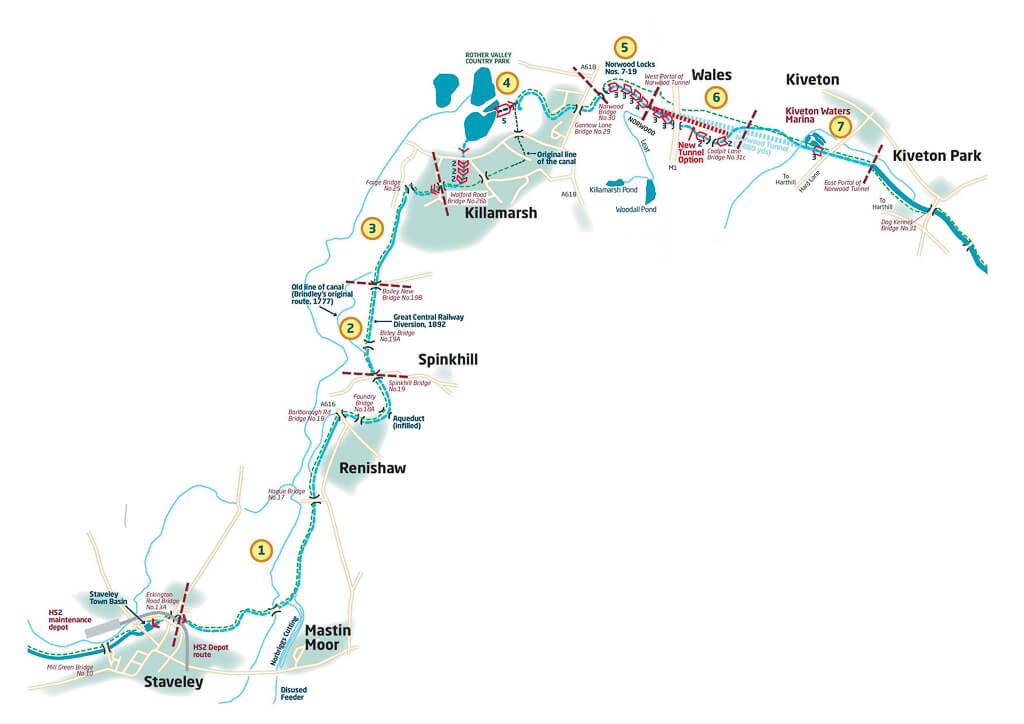
Section 1: Colliery Link
This joins the sites of the old Hartington Colliery and Renishaw Colliery. The next section is Staveley Puddlebank which has been ravaged by subsidence and was bulldozed in the 1970s. There will be a steel trough aqueduct over the river Doe Lea. The section through Renishaw will be restored by Chesterfield Canal Trust’s volunteers, hopefully starting later this year. It will include remodelling the unsuccessful restoration next to the new housing estate done in 2008.
Section 2: Great Central Railway Mile
This runs from Spinkhill Lane along the 1890s diversion constructed by the adjacent railway (once the Great Central Railway, now the Trans Pennine Trail) to Boiley Old Bridge. Spinkhill Lane Bridge will be replaced.
Section 3: Forging into Killamarsh
This runs from the end of Railway Mile to Walford Road. Gallas footbridge will be reinstated and Forge Bridge will be restored. Two new locks will be built east of the old Lancashire, Derbyshire & East Coast railway bridge to enable the canal to pass under Walford Road.
Section 4: Killamarsh
The Trust expects this to be the last section to be delivered. In the 1970s, houses were built on part of the original canal line, so the new route goes into Rother Valley down a wide area of grassland left following the rebuilding of the Bungalows housing estate. Three pairs of double locks will take the canal down to Quarry Lane before going under Sheffield Road in a box culvert.
The canal will then go through Nethermoor Lake via a guillotine flood control gate which will be remotely controlled in conjunction with the Rother Valley flood defence system.
To get back up to the original level, the Moorhouse Flight will have six staircase locks. However, an alternative would be to build a boat lift which would be a major tourist attraction with a visitor centre, boat rides and a café. A new Gannow Lane Bridge will take the A618 over the canal.
Section 5: The Cradle of the Canal
The Norwood Flight of 13 locks lifts the canal 76 ft in just under three-quarters-of-a-mile and is a wonder of the early canal age. They are arranged in three three-rise and one four-rise staircases. These are separated by three ponds and side-ponds which regulate flow and provide water storage.
Section 6: Up or Under
This section runs from the western portal of the Norwood Tunnel to the western edge of Kiveton Country Park, passing under the M1. There are two plans – either to lock up to the motorway and use an existing culvert or to build a new tunnel of about 630m, avoiding the need for locks.
Section 7: The Tunnel Reborn
This section runs from the western limits of the Kiveton Country Park to the existing canal at the eastern portal of Norwood Tunnel. The route within the Kiveton Colliery site already exists. Kiveton Waters ponds are currently used for fishing but will become a marina once the canal is restored. The final section will use the existing eastern section of the Norwood Tunnel extended to get under Hard Lane. After that it is literally downhill all the way to the River Trent.